Trip Summary: 2012 Hike from Wonder Lake to McGonagall Pass
· Steve Chisgar, Clint Chisgar, Jim Barr
· Left the Denali park entrance on camper bus: 2:00pm, Sunday Sept. 2, 2012.
· Bus dropped us off at the McKinley River Bar trailhead at 7:30pm on Sunday, Sept. 2, 2012.
· Hike began at 7:40pm on Sunday Sept 2, 2012.
· Hike ended at 11:00am on Thursday, Sept. 6, 2012.
· Totals: 41 miles hiked in 5 days. 4 nights total in backcountry. 3 different campsites (1 north of McKinley River, 2 south of McKinley River.
After failing to reach McGonagall Pass in both 2010 and 2011, I felt certain that 2012 would be different… and certainly the 2012 hike was “different”. I had to write-off the previous two years as warm-ups: in 2010 I only made it a mile passed Turtle Hill (alone). In 2011, we were near Upper Cache Creek when my hiking partner got sick (dry heaves, nausea), and we decided to end the hike early.
In Feb-March 2012, I told my hiking buddies Steve and Clint that I would be returning to Denali for a third try. They discussed it and quickly decided that they would again accompany me on the hike, for which I was very happy. I began referring to this hike as the “3rdAnnual Labor Day McGonagall Pass Hike”. After getting sick in 2011, I think Steve felt there was some unfinished business to do.
I began physically training for the 2012 hike in early August – several weeks before the trip. In those training weeks, I walked/ran a total of 71 miles to prepare. During the final week before the hike, I walked 28 miles with either both my backpack and hiking boots, or just my boots. By the time we left for Alaska, I felt 100% confident that I was ready.
Just eight days before we left home for Alaska, Richard White a 49 year old man from San Diego was backpacking alone near the Toklat River (read about our 2011 bear experience along the Toklat River above). White was fatally mauled by a grizzly bear and later discovered by other hikers. It was eerie to learn how much I seemed to have in common with White:
1) He was hiking alone (which I had done in 2010),
2) White was roughly the same age as me (49 – I was the same age when I hiked solo in Denali),
3) White left behind a wife and young daughter.
The Park Service blamed the incident on White being too close to the bear and continuing to take pictures (without slowly retreating and speaking in low, calm voices- -as advised by the Park Service). I was not very satisfied with that conclusion. The simple truth is that bears are unpredictable animals and we’ll never know exactly what happened. The mandatory training videos that the Park Service requires all backcountry hikers watch, points out (and I quote): “charges are terrifying, but most are bluffs intended to intimidate you, not to start a fight”. Did this happen? When the attack was imminent, did White fall to the ground and cover? We simply will never know. It was only when I learned that White carried neither bear spray nor a firearm (he only carried a bear whistle), that I came to believe that his death was preventable. Yes, it would come out that he took too many pictures. But in my opinion, it was a perfect storm of fate and poor decisions: wrong bear at the wrong time, too-close for too-long, no bear spray, no gun, no human help.
 |
| Site of fatal bear attack. |
 |
| Site of fatal bear attack at Toklat River |
Regardless of the exact events, Park Service Rangers will never again be able to claim: “Denali has never experienced a human fatally at Denali due to a bear attack”. Additionally, the Park Service’ required video needs to be updated to remove this claim.
SUNDAY, SEPTEMBER 2, 2012
SUNDAY, SEPTEMBER 2, 2012
The three of us arrived at the Denali Backcountry office by 9am. We watched the mandatory (every year) training videos and listened to the mandatory safety talk. For the first time in three years, the Ranger giving the safety talk did not come across as arrogant or demeaning to the hikers. She was kind and seemed to love the wilderness as much as we did. In years past, I wasn’t sure if the Rangers actually wanted to be there. Afterwards, we secured our permits and packed our backpacks. We made our “final phone calls”to home from the parking lot, locked the rental car, and boarded the camper bus at 2:00pm. The drive to Wonder Lake seemed longer than usual and we asked the driver to drop us off at the McKinley Bar trailhead instead of at the campground. Steve, Clint, and I played a little game where the first person to spot a bear would get the rest of the Subway cookies that Steve had bought earlier (Subway’s Oatmeal cookies are good). Clint spotted a bear first and I’m sure it didn’t take him one minute to toss them down (there were about 3 cookies + crums).
I’ve always enjoyed the ride to Wonder Lake on the camper bus because of the people I have met during the 5 hour ride. Some really interesting people ride that bus. At the Eielson Visitors Center a couple guys got on the bus that are worth mentioning. It was really, really windy and really, really cold at Eielson. So, these two guys hop on the bus and sit right behind us. We noticed that one of them didn’t have any shoes on. Bare feet! Wow. I wondered if I would learn the answer to the obvious question in my mind: “Was this guy a stud or an idiot?”
Turns out, they were both from Brooklyn, NY.
Having settled that question, we chatted with them for the short ride from Eielson to Wonder Lake. This was their third year to camp at Wonder Lake. They were kind enough to show us some really great pictures of grizzly tracks which were left in the river silt. When we told them we planned to cross the McKinley River that evening, I noticed a difference in their tone…I can read people pretty well and it was obvious that they were asking themselves: “Are these guys studs or idiots?” When we added that we intended to backcountry camp 4 nights and hike over 40 miles, I could see the light-bulb go off:
“Studs”, they thought. “Absolutely, without question, definitely, and obviously… studs”. I’m 100% sure that’s what they were thinking.
We never did get around to asking the one guy “why the bare feet?”, and “how’s that working out for you?” and I wish we had asked him about that. When the driver dropped us off at the trailhead and the barefoot guy saw where we were going, he yelled out the open bus window: “you got room for two more?”
Reminder to self: It’s Ok to be crazy, it’s not Ok to be stupid.
 |
| From the park road - a view toward our hike: with a grizzly in the way. |
We took two pictures at the trailhead: one regular, one crazy (see below). The picture’s timestamp was 7:34pm Alaska time. 24 hours earlier we were just landing in Anchorage. But… under less than optimal conditions (late start, tired, long bus ride) we began the hike. The 2.4 miles down to the McKinley River went quickly and at 8:45pm or so we arrived at the river bar (we obviously weren’t lolly-gagging). After arriving at the river bar we had a quick discussion about crossing the river (which last year had taken two hours), and we decided to wait until morning to cross. We set-up camp and hit the sack around 9:30pm or so, the sun had already set, but there was still some light until around 10pm.
 |
| Crazy. |
 |
| Regular |
LABOR DAY MONDAY – SEPTEMBER 3, 2012:
We woke up, had a little breakfast (Oatmeal and Starbucks Via for me), packed up camp, and started the hike. The first task was to cross the dreaded McKinley River. The McKinley River is about a mile wide, but made up of tens of ‘braids’, which are 15-30 feet wide each. The deepest that any one braid was: just over the knees. Last year, I had difficulty with the coldness of the river and had to sit down and rub my frozen feet. This year, I decided to try SealSkinz Waterproof (neoprene) Socks and they worked pretty well. They were not really waterproof because the depth of the river was higher than the top of the socks, but they did keep the thin layer of water next to my feet a few degrees warmer than the 36 degrees water temperature. We crossed the river in just over an hour without much difficulty, and made our way to the “trailhead”.
Using the word“trailhead” and “trail” to describe the path needs some explaining. Officially (according to the National Park Service) there is no ‘trail’ south of the river - - at least that’s the impression I have gotten from Rangers over the past three years. In fact, even at the south end of the McKinley Bar Trail (just at of the river bar) - - the old NPS sign and ‘three-trees marker’ that once existed there have been completely removed (they were there in both 2010 and 2011). Once you’ve crossed the river it is necessary to hike up-stream about 0.5–1.0 mile to reach the ‘trailhead’, which is completely unmarked and unsigned. Even the hiker-built Cairn stone that existed in 2010 has been removed by Rangers (surely to preserve the wilderness experience). I really don’t care if it’s marked or not… because now I know the lat/long coordinates. Here they are: trailhead coordinates: 63°24'45.92" N 150°47'22.22" W.
The“trail” to McGonagall Pass is described by the NPS this way:
The unmaintained 'climber's trail' is very difficult to find on the north side of the McKinley River Bar and is not maintained. Hikers should travel from Wonder Lake Campground via the established McKinley Bar Trail. The start of the unmaintained 'climber's trail' is across the river and about 1 mile upstream (i.e., east) from where the McKinley Bar Trail meets the McKinley River. Many hikers find it easier to find from Turtle Hill; so if you have trouble finding it along the river, head for the summit of that small hill.
I have to disagree with the last part of the last sentence… DO NOT just take off for Turtle Hill unless you are prepared for hours of really difficult bushwhacking. Even though the ‘trail’ is not maintained, you will come to appreciate what little is there… and you’ll appreciate it very much.
Anyway, the hike up to Turtle Hill following the trail still took us 2- 3 hours - - and we were tired by the time we reached the top. Google Earth shows it’s about 2 miles from the trailhead to Turtle Hill, with a significant elevation gain (1,000’). The hike from the river bar to Turtle Hill was probably the most difficult hiking during the entire 5 days. Upon reaching Turtle Hill, we had lunch and a well-deserved rest.
 |
| Having lunch on Turtle Hill |
 |
| After lunch near Turtle Hill |
After Turtle Hill, the hiking was easy down to the Clearwater Creek, but the Clearwater seemed further away than we remembered from last year. Approaching the Clearwater Creek we crossed paths with (5) – yes, (5) National Park Rangers hiking back from a backcountry patrol. They were coming from Clearwater Creek, we were heading toward it. In that part of the hike you can spot another party from about a mile away. We spoke with them several minutes, they checked our permits, and then we all kept hiking after an enjoyable chat. Clearwater Creek is aptly named… as opposed to the McKinley River you can see the bottom of the Clearwater… a feature which helped us stay away from any big holes or rocks. After crossing the Clearwater Creek, we made a straight line hike for the first Cache Creek crossing (we did not attempt to find the trail in the low-lying river bed between Clearwater and Cache). Just head south-west and you’ll eventually find the trail again, which is what we did.
It was getting late in the day by the time we crossed Cache Creek. Don’t be fooled by the NPS description of Cache Creek – it was pretty difficult when we crossed it and we could have easily had problems due to the fast current (but we made it ok). Once you cross the Cache Creek, the trail parallels the creek but is about a half-mile away. The trail curves back up the hill of the ridge directly in front of you. We hiked all the way to the long skinny ridge which has a huge boulder on it, and once there - - we began to look for a campsite. Total hiking on Labor Day: 11.6 miles.
TUESDAY – SEPTEMBER 4, 2012: (Summit Day J)
Tuesday was a ridiculously exciting day - - filled with challenges, obstacles, and by the end of the day - - more than a fair amount of concern. This day was probably the most action-packed and memorable day ever for me in Denali. Looking back on this day, it’s hard to believe how much happened in one day.
 |
| Wolf scat along the trail - near middle Cache Creek. |
Early in the morning, we decided to leave our camp set up where it was (tents, pads, sleeping bags, etc) and only take a ‘day-pack’ (which unfortunately was still our big backpacks) to the ‘summit’ of McGonagall Pass. It made a huge difference in weight that we had to carry. We followed the trail down from our camp and once again found that we had to cross Cache Creek, which was simple. What wasn’t very simple was finding the trail on the other side of the creek - - and it took 15 minutes to re-find the trail. Once we crossed the Cache, it was simple hiking for a mile or so. We were psyched-up and ready for some serious elevation gain!
Unfortunately, our excitement was about to come an abrupt halt. Just as we were approaching the Upper Cache Creek valley before arriving at the base of McGonagall Pass… we saw something that put our entire trip in doubt. Clint saw them first. Directly ahead of us –approximately ¾ mile away - - he saw two large animals running down a steep embankment and disappear into the brush. Steve also saw the movement and we discussed what they were. Steve got out the binoculars and we quickly confirmed: two large grizzly bears were directly on the trail in front of us. One was a large, darker-brown (normal-looking) grizzly. Did I say ‘large’? The other, however, was a blonde grizzly bear. The blonde grizzly appeared to be slightly smaller than the brown one, but the brown one appeared to be full-grown. The discussion changed from “we should make the Pass by 3pm”to “should we just go back to camp?” One thing was certain - - we could not just go on along the trail. It would have been reckless to continue forward because we surely would have encountered them.
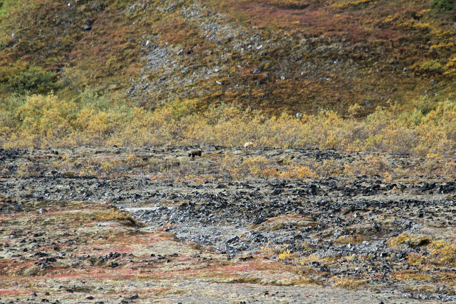 |
| Two large bears encountered along the trail |
 |
| Two bears ecnountered along the trail. |
Although this was only our second ‘bear experience’ in the wilderness we didn’t panic. Seriously, if you find yourself in this situation panic is the last thing you want. We discussed our options and remembered the NPS training videos. Since the bears had not yet noticed nor seen us, we decided to hike up the mountain to our left to get a better view of the bears. We thought this would also allow the bears to pass us along the trail if they wanted to proceed northward. Once we climbed 200 yards or so up the mountain, we stopped and re-located the bears. They were still foraging around near the end of the valley. They appeared to have moved 50 yards or so toward us, but they did not appear to have noticed us at all. I think this is where we decided to hike a little higher up the mountain and then hike along the side of the mountain (parallel to the bears) until we passed the bears, then we would drop back down to the trail. It appeared we would be set-back a few hours by this detour, but it was the best option for us.
So…we found ourselves hiking higher up the side of a mountain - - once we were about half-way up -- we made a right-turn and we began to hike along the side of the mountain toward the bears. We closed the distance between us and the bears to about ½ mile or less (horizontally), but we were now a couple hundred feet above them.
It was near the point of passing the bears (horizontally) that we stumbled upon what we think was the bears’ den! While hiking along the side of the mountain, we literally hiked on top of a freshly dug, large hole. It was [mostly] circular, about 6-7 feet across, and about 5 feet deep. Steve and I thought it likely to be the bear’s den. Clint walked back and actually stood in it. I regret not getting out my camera for that picture! We literally walked on top of it. We didn’t disturb it in any way. We stayed at pretty much the same elevation for about a total of a mile before beginning to cut back down the mountain toward the path. We kept a constant eye on the bears and I don’t think they ever saw us. Perfect.
It was around 2:30pm by the time we dropped back down to the trail and we stopped hiking for lunch. We found ourselves at the confluence of Upper Cache Creek with the creek that came down from Oastler Mountain! We were nearing the base of McGonagall Mountain! I guessed that we still had three miles to hike, but we knew that it would involve 2500-3000 feet of elevation gain.
We stopped for lunch but found ourselves in a hurry to eat so we could get back on the trail. We fetched water from the Cache Creek without pumping. Also at this spot– we made another cache - - everything that would not be absolutely necessary would be left here. Basically meaning our packs would only have water and cameras. No extra clothes, no food, no cook stove.
There was a sense of urgency that we all felt. We were also more tired than we had expected. I was certain that our toughest hiking was still ahead of us. Another thing that we began to discuss - - we would have to return along the same route to our camp - - meaning we would have to [once again] pass-by the bears - - assuming they were still there. What if the bears had returned to their ‘den’, were angry and then happened to see hikers 300 feet below them? What if it was already dark? Yikes.
I had serious doubts if we could complete the task before us: make the climb up to McGonagall Pass, hike back to the spot where we had lunch, then return to our camp… all before dark? No way. At this moment, it occurred to me that we would very likely be hiking in the dark.
We started hiking again by crossing the Upper Cache Creek confluence and again needed to find the trail on the other side. Finally, we saw that it headed west (to the right) pass the base of Oastler Mountain. The landscape was already really changing. We also started gaining elevation. We hiked about a mile or so and we noticed a definite lack of trees and a lack of foliage such as the Alder bushes (thank goodness - - I hate the Alder bushes along the “not-a-trail”). What was left to hike on was rock. We really cruised around the side of Oastler Mountain.
 |
| Google Earth view of McGonagall Pass |
 |
| Nearly the same view, but from the ground. |
We began to see the base of McGonagall Mountain at the bottom of what we called the ‘right arm’ of McGonagall. From Google Earth, you have to really use your imagination, but on the trail, McGonagall Mountain looked just like one of those bed rest pillows with arms. So, our task was to ‘turn the corner’ at the base of the right arm of McGonagall. By the time we got there, there were no more trees, no tundra, no grass and extremely little foliage, it was nearly all rock. The wind began to kick up, and it was definitely colder than down lower. All that remained was about a mile straight up.
It seemed to take forever to round the right-hand corner of the base of McGonagall Mountain. It kept going on and on and on… and up and up and up. However, once we were facing the Pass – heading nearly straight west… we were excited knowing we were nearing the goal. The landscape now looked like we were on another planet – with mountain walls surrounding us. We completely lost the view of Wonder Lake and the lower lands we had hiked. We were also no longer concerned about bears because we thought they were much smarter than to be where we were. From Google Earth– you can get a sense of the view, but I disagree with the landscape that Google Earth shows. It appears that Google Earth overlaid a lot of the foliage on top of the mountains. Believe me - - it doesn’t look like that - - there is nothing green about it… it’s ALL rocks all around you.
It’s time to talk about how tough this last part of the hike was. The elevation gain alone was tough, tough, tough. We were hiking about 100 yards at a time, then stopping to catch our breath. That interval became shorter and shorter as we hiked higher. Then, there was the wind. The wind picked-up as we rounded the base of McGonagall Mountain and steadily increased as we climbed up. By the time we were at the top, we were nearly crawling due to the constant wind. The gusts that occasionally happened would cause each of us to huddle under the nearest boulder- - some of which were huge. Knowing we were close to our goal kept us moving.
However, we were so far behind schedule that we set a time limit of 5:30pm as the drop-dead time where we HAD to turn around and begin the hike back to camp (we estimated 6 hours to hike back + any “bear time” of walking around the bears). At 5:24pm I had had enough. I turned to Steve to ask him the time. Clint took off by himself for another 100 yards. Both Steve and I followed. It was kind of the last hurrah as we didn’t make it much further than that. Our final GPS reading was recorded by Steve at 5:28pm, 63deg 14’ 04” W, 150deg 43’39” W. And we turned around. We took a couple pictures at the top. The pictures below do not do justice to the amount of discomfort we were under. Cold, snowing, tired, sore, concerned about the return hike. Oh, and I forgot the blowing grit and sand in the wind. Two days later, I was still picking the grit out of my hair. My right eye was noticeably bothering me by the grit/sand was carried by the wind. I believe I was starting to get frostbite in my first three fingers on each hand (I didn’t wear gloves). Another reason we knew we were at the top because Cache Creek was merely a dribble - - you really couldn’t even call it a creek - - you had to look deep between the rocks to see any water. [Update note: After returning home, the tips of three of my fingers turned black and peeled – a certain sign of beginning frostbite].
 |
| Steve and Clint at the pass |
 |
| Jim and Clint at the pass - yes, that is snow. |
I wish I could say that the return trip to camp went smoothly. When we were almost all the way down the Pass - - a wind gust knocked Clint and I off our feet. Both of us fell on to rocks – me hurting my right shin, Clint hurting his knee. Steve said he wasn’t knocked to the ground - - but that he “dropped to the ground” by his own power. I certainly did not believe him :) . Even in pain, we had fun together. It took several minutes before we resumed hiking. I don’t want to think what would have happened if any of us had broken a bone or had a more serious injury. At this time, the Wonder Lake Campground was the nearest help - - and it was 17 miles away across several strong rivers. By my estimate, we had to “drop to the ground’ 5-10 times due to the wind gusts (most of them on the way up).
Eventually, the foliage returned, Cache Creek became an actual creek, and we began to see the spot of the confluence and our cache from lunch. We had a little trouble crossing Cache Creek at the confluence, but made it safely back to the cache –which our extra clothes, cook-stove, etc remained safely stowed under a rock. At least we knew the bears had not found them. Unfortunately, it was 7:30pm when we stopped… I think we took a 30 minute rest. We packed up everything into our packs, loaded them on our backs, and started back to the camp.
We hadn’t walked 30 feet when Clint pointed and said “They’re they are!” Clint had re-spotted the two bears. They hadn’t moved more than a mile since we left them earlier. Fortunately, they were now on the other side of the creek. We studied the situation and made the decision to take the trail (and not hike around them on the mountain). Steve only agreed to take the trail if we “boogied” until we passed the bears. Both Clint and I nodded our heads, and we took the trail and passed the bears in about a mile or so. The trail was great through this stretch and made for easy hiking. We kept an eye on the bears… they never seemed to noticed us but were still intent on their foraging. Also, we noticed that the wind was at our backs - - which only helped. Once we passed the bears, we slowed up a little and maybe even stopped to look back at them. This was a huge sigh of relief for us, and a big obstacle out of the way. However, it was already around 9pm and we still had several miles to hike before returning to our tents.
 |
| The other-worldly feeling near McGonagall Pass. |
We hadn’t walked 30 feet when Clint pointed and said “They’re they are!” Clint had re-spotted the two bears. They hadn’t moved more than a mile since we left them earlier. Fortunately, they were now on the other side of the creek. We studied the situation and made the decision to take the trail (and not hike around them on the mountain). Steve only agreed to take the trail if we “boogied” until we passed the bears. Both Clint and I nodded our heads, and we took the trail and passed the bears in about a mile or so. The trail was great through this stretch and made for easy hiking. We kept an eye on the bears… they never seemed to noticed us but were still intent on their foraging. Also, we noticed that the wind was at our backs - - which only helped. Once we passed the bears, we slowed up a little and maybe even stopped to look back at them. This was a huge sigh of relief for us, and a big obstacle out of the way. However, it was already around 9pm and we still had several miles to hike before returning to our tents.
The sun was beginning to set and darkness would soon be upon us. We had about 4 miles left by my estimate. The hiking was easy for the next mile or two. We came over a ridge and saw something that caught our eye directly along the trail just 300 yards in front of us. It was a tent. As we came closer, we realize that it belonged to two hikers that we had run into way back before Turtle Hill – close to the McKinley River. Friendly couple – he was from Chicago, she was from Paris. They were trying to make it to McGonagall Pass also but were at least a day behind us. When we passed them on Monday, they were very friendly with us and we even joked about Alabama in a good natured way. Even though the man said “I’ve been to Mo-buhl”, like Mobil Oil, we went along with him (any Yankees who are confused - - Google: “Mobile, AL pronunciation”). I even told them the meaning of the semi-secret Alabama term: “I went to L.A.” which in Alabama means: “I went to Lower Alabama”… and the lady from Paris loved it. As we came over the ridge and she realized who we were, she started greeting us with “L.A.!!! L.A!!! We chatted with them for several minutes warning them about the bears, and telling them that we encountered strong winds and snow at the Pass. We had to hurry-on because by the time we left them, it was dark and it was time to get out the headlamps and flashlights.
Well, Steve had a flashlight, and I had a headlamp. Clint had the hardest job - - having to hike in the dark without either. We hiked the next mile in the twilight, and by the time we reached the last crossing of Cache Creek it was very dark. We knew that our campsite was just on the ridge past Cache Creek, but it’s not like Cache Creek is just one stream… at this point, it is more like 5 streams in a winding swamp/marsh filled with Alder bushes. We searched diligently for the trail, but lost it after crossing the marsh. This presented a major obstacle for us - -hiking in pitch dark, and no trail. Furthermore, we did not have the coordinates of the campsite. We could not really see where we were going at all. This was probably the most stressful part of the hike, but it was time for ‘cool-heads’ to prevail. We knew we should continue paralleling the creek – because eventually we would stumble across the trail. We believed that the trail HAD to be there – it was now just a matter of us literally running in to it. It took longer than any of us would have liked, but Steve (who did a fabulous job of leading this motley crew of three) finally walked across the trail. Remember, this is still the “not a trail” and was only about 9 inches wide where Steve found it. Nevertheless, we were thrilled to have found the trail… I mean ‘path’.
From there, we proceeded up the ridge, yelling “Hey bear!” one after another. Steve would lead it, then Clint’s “Hey Bear”(Clint was still walking without the help of a flashlight or headlamp), and then my “Hey bear”. It’s a crazy, wacky feeling hiking at night in bear infested swamps, it’s just so wrong. We had hiked another ½ mile when Steve saw two eyes ahead reflecting in his flashlight. Another step or two, and he saw three eyes reflecting in his flashlight! We kind of joked - -we’d never seen a bear with three eyes - - maybe it was a wolf or two.
Neither, it was Steve’s tent. We had reached the camp. It was 10:30pm.
I had never been so happy to crawl into my sleeping bag. I was asleep by 10:35pm or so.
Unfortunately, this momentous day was not over yet. The wind that was at the Pass now came down to the ridge we were camped on and it did so with a fury. Just after I had fallen asleep, the wind kicked up such a stir that our tents began pushing over. The tent stakes and strings held firmly, and I felt “something” hit my nose!!! It was the wall of my tent, pushed so far over that the tent wall was brushing my nose. Wow. The wind continued most of the night. Needless to say, it was a rest-less night. In the morning, Steve noticed that his tent poles were bent into a permanently curved shape from the wind (and his tent was a good quality tent).
So, that’s “all”we did on Tuesday. That was quite a day.
Total miles hiked: 12.4
WEDNESDAY – SEPTEMBER 5, 2012:
It was a long night. The wind kept blowing hard all night long. I woke up at 6am, and went immediately back to sleep until 10am. We packed up camp and headed back toward civilization which was now only about 13 miles away. We talked about whether or not we could make it back to the McKinley River that same day or not. We made it to Turtle Hill by 5pm. We knew it was only a couple more miles down to the big river bar. It began raining. Fun times hiking in the rain in Denali, I’ll sure tell you that. We were all drenched, cold, and tired by the time we reached the river bar. Since we were already wet and miserable, Clint wanted to cross the river that night but I could not go further. We camped in Unit 19 under the cover of some bushes.
As we walked down from Turtle Hill to the river bar, I realized that I might not be back to this location in quite some time, if ever. My thoughts went back to my two previous attempts at this hike. I recalled the first time I stepped out of the view of Wonder Lake - - how remote it felt. I felt that I was at the end of the earth. When the Caribou visited me at dinner time two years ago, I was hooked.
I have enjoyed Denali’s main attribute of complete wilderness. I have come to believe that Denali’s difficulty in reaching (5 hour drive north of Anchorage) + the bus ride to Wonder Lake (another 4-6 hours) has historically protected Denali. And expanding Denali to 6million acres in 1980 was Jimmy Carter’s best move as President [by far].
Total miles hiked: 10.1.
THURSDAY – SEPTEMBER 6, 2012:
We arose early and packed up camp. We headed off to cross the river at around 8am. It took almost exactly one hour to cross the McKinley, without incident. We located the trailhead of the McKinley River Bar Trail, which actually is a maintained, approved, and recognized trail. We were back at the Wonder Lake Campground Bear Locker / Picnic area by 11:30am and had a nice lunch.
We arose early and packed up camp. We headed off to cross the river at around 8am. It took almost exactly one hour to cross the McKinley, without incident. We located the trailhead of the McKinley River Bar Trail, which actually is a maintained, approved, and recognized trail. We were back at the Wonder Lake Campground Bear Locker / Picnic area by 11:30am and had a nice lunch.
 |
| Five fingers for five nights in the backcountry. |
We also found out that the NPS had closed the Park Road at Toklat due to snow. Regardless, we were able to take the 2pm camper bus back to the Park entrance. It was 8:30pm or so when we got back to the rental car and had finished returning all of the bear cans to the backcountry office.
 |
| Snow at Eilson |
 |
| Snowman at Eilson |
When we woke up the next morning in Anchorage, we found out that high winds in most of Alaska had caused lots of damage. The gusts in Anchorage were recorded at 130mph. I wouldn’t make this up - - see http://www.accuweather.com/en/weather-blogs/weathermatrix/extreme-alaska-storm-cuts-anchorage-off-from-world/71969. Steve and I tried to guestimate the wind speed at the top of McGonagall Pass, but it’s nearly impossible to say what they were. I do know that the strongest gust knocked [at least] two of us off our feet.
I’ve hiked other National Parks like Yosemite, Glacier, Mt. Rainier, Rockies, Grand Canyon, and others. Denali will always hold a special place for me. Glacier probably has better views, Yosemite has Half-Dome and El-Capitan, Mt. Rainier is amazing, the Rockies are like a park in the suburbs. But Denali has it all.
Will I return? 2013 is the 100th year anniversary of the first successful summit expedition of Denali.
Click on this link to continue to Chapter 4 - 2013: